

国道314线小草湖至库尔勒公路工程测量设计
摘 要
数字化测图是近几年随着计算机、地面测量仪器、数字化测图软件的应用而迅速发展起来的全新内容,已广泛应用于测绘生产、水利水电工程、土地管理、城市规划、环境保护和军事工程等部门,并被广大用户所接受。而GPS做为数字化测绘的先进技术应用于公路测量则是公路外业勘测的一项重大革命,其应用及开发的前景十分广阔。尤其是实时动态(RTK)定位技术在公路测量中蕴含着巨大的潜力。
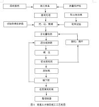
本文从GPS卫星定位系统的概述入手,先介绍了GPS卫星定位的原理,接着列举实例对GPS在公路测量中的应用及其对公路勘测的巨大推进作用做了详述。主要是对国道314线小草湖至库尔勒公路控制网的测绘过程做了详细介绍,并且GPS在公路施工测量应用是一项在工程施工阶段进行的测量工作,也是工程测量的重要内容。包括施工控制网的建立、公路的放样、公路变形观测等。施工控制网是为工程公路的施工放样布设的,分为平面控制网和高程控制网。平面控制网一般是三角网和导线网,在工业公路场地上也可以是公路方格网。高程控制网多是水准网。施工控制网常分级布设。首级网覆盖整个工地,加密网根据工程放样的具体需要布设,点数多、使用方便。平面施工控制网常采用公路坐标系,也称施工坐标系,即坐标轴与主要公路或主要工艺流程的中心线相平行的平面直角坐标系。它同测绘地形图时的测量坐标系不一致。放样用的控制点坐标与待放样点的坐标不一致时,须把坐标换算统一,再计算放样元素。公路施工测量是把设计图上的公路的空间位置和形状标定到实地上去的测量工作,又称施工放样或测设。测设点位常用极坐标法、直角坐标法和交会法。为保证公路在施工、使用和运行中的安全,以及为公路的设计、施工、管理及科学研究提供可靠的资料,在公路施工和运行期间,需要对公路的稳定性进行观测,测定公路及其地基在公路本身的荷载或受外力作用下,一定时间段内所产生的变形量及其数据的分析和处理工作,这就是公路的变形观测的主要任务。
关键词: 国道314线小草湖至库尔勒公路工程测量;GPS控制网;中线测量;护坡稳定性监测
ABSTRACT
. The digitized mapping is in recent years along with the computer, the ground survey instrument, the brand-new content which but the digitized mapping software application develops rapidly,Has widely applied in departments and so on mapping production, water conservation water and electricity project, land management, urban planning, environmental protection and military engineering, and is accepted by the user community. But GPS does for the digitized mapping vanguard technology applies in the highway surveying is a significant technological revolution which the road field operation surveys, its application and the development prospect is extremely broad. The real-time dynamic (RTK) localization technology is in particular containing the huge technical potential in the highway surveying.
This article from GPS satellite positioning system outline obtaining, introduced first the GPS satellite positioning technology principle and the work regulations, then enumerated the example which surveyed to the road have made the specification to GPS in the highway surveying application and the huge advancement function.Mainly was the outer ring road control net mapping process has made the detailed introduction to the fidelity city urban district north, finally has made the forecast to the GPS technology in the highway surveying application prospect.A measurement of road construction projects in the construction phase of the survey work, and is also an important part of engineering measurements. Including construction of a control network, roads and its subsidiary structures of setting-out survey, roads deformation observation. Construction control network was laid for road construction Fang yang divided into two control networks and elevation control network.
Horizontal networks and control networks are generally triangular wire network. Elevation control networks are standard network. Construction control network regular classification lay. Perform network covering the entire site, encrypted network setting-out survey according to the specific needs of the project laid, and points more, user-friendly. Horizontal construction often used to control network construction coordinate system, also called the construction coordinate system that coordinates with the main axis parallel to the axis lines or major roads parallel rectangular coordinates of the plane.
Mapping topographic map with the coordinates of measurement inconsistencies, setting-out survey used to be the control point coordinates with the coordinates inconsistent setting-out survey points, the coordinates conversion to unified, and then calculate setting-out survey elements. Road construction surveying is to design the road and its subsidiary structures, the location and shape of space demarcation work to the field strength measurements, or measurements as construction setting-out survey located. Geodetic coordinate’s law is commonly used for point spaces, rectangular coordinates law and the trade fair act. To ensure that roads in the construction, use and operation of the security, as well as road design, construction, management and scientific research to provide reliable information on road construction and operation, the need for the stability of the road observations, measurements road and the road itself in the foundation or by forcing the load, certain time periods and the resulting distortion of the data analysis and processing, which is the main road deformation observation mission.
Keywords: horizontal control ; data process ; setting-out survey ; GPS control net ; center line survey.
目录
第一篇 国道314线小草湖至库尔勒公路工程测量中的应用 2
1 GPS在公路测量中的应用 2
1.1 GPS在公路工程测量的任务和内容 2
1.2 公路施工测量的要求 4
1.2.1 公路施工测量的一些基本准则 4
1.2.2 测量记录的基本要求 4
1.2.3 计算工作的基本要求 5
1.3 公路施工测量的基本原则 6
1.3.1 先整体后局部 6
1.3.2 逐步检查 7
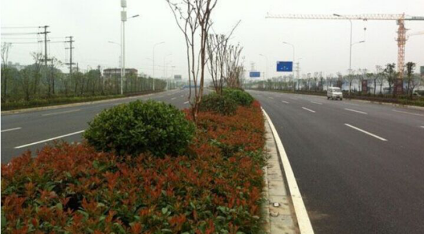
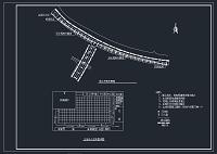
2 项目测区及概况 7
2.1 项目简况 7
2.1.1 测区概述 7
2.1.2 公路等级 8
2.1.3 施工进度安排 8
2.2 导线测量 10
2.2.1 导线测量平差概述 10
2.2.2 导线平差计算 10
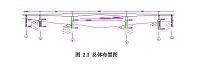
2.3 中线要素计算 12
2.3.1 里程的确定 12
2.3.2 中线坐标计算 12
3 GPS在项目施工控制测量中应用 15
3.1 项目施工中准备工作 15
3.1.1 GPS网的布网原则 15
3.1.2 GPS控制网的图形条件 16
3.1.3 GPS网的控制测量方案的实施 17
3.2 公路施工平面控制测量的内容 21
3.2.1 导线测量 21
3.2.2 交会定点 24
3.3 项目的施测结果数据分析及整理 27
3.3.1施测结果数据分析 27
3.3.2 GPS数据处理 30
3.3.3 GPS测量在高程控制测量中的应用 33
4 GPS在国道314线小草湖至库尔勒公路施工测量中的应用 34
4.1 公路施工测量放样的实施 34
4.1.1 放样前的准备及要求 34
4.1.2 公路中桩测量 35
4.2 公路中线的施工放样 36
4.2.1 控制点复测 36
4.2.2 用导线控制点恢复中线 39
4.2.3 用路线控制桩恢复中线 40
4.2.4 纵断面的施工放样 45
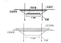
4.3 路基路面的施工放样 46
4.3.1 路基横断面施工放样 46
4.3.2 路基施工阶段各层次的抄平方法 48
4.3.3 路面施工放样 51
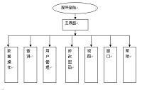
6 总结及感想 62
[17]赵宴辉,聂亚杰,刘二平,朱春来监控系统中OPC客户端程序设计与实现[J]
微计算机信息,2010
[18]OPC 基金会。OPC Data Access Custom Interface Standard Version2.0[S]
[19] Myoung HunKim and Hong ShikPark.An Integrated Scheduling for Multiple Loss PriorityTraffic in E-PON OLTSwitches LectureNotes in Computer Science.2003.
[20]杨本玉,朱伟兴,王东宏 基于 OPC 技术的养猪场实时监控系统设计[J]低压电器 2008,7 30-33
[21]张烨林, 陈德海 浅议 OPC 技术应用 [J]科技信息 2008,266-67
参考文献
[1]李青岳主编:工程测量学.北京:测绘出版社,1984
[2]张正禄主编:工程测量学.武汉:武汉大学出版社,2002
[3]陈龙飞,金其坤.工程测量.上海:同济大学出版社,1990
[4]秦昆,李裕忠等.桥梁工程测量.北京:测绘出版社,1991
[5]彭先进.测量控制网的优化设计.武汉:武汉测绘科技大学出版社,1991
[6]公路勘测规范JTJ061-99.中华人民共和国行业标准.北京:中国交通出版社,1999
[7]周忠谟,易杰军编著.GPS卫星测量原理与应用.北京:测绘出版社,1992
[8]张凤举,王宝山编.“GPS”定位.北京:煤炭工业出版社,1997
[9]国家测绘局颁布.全球定位系统(GPS)测量规范.北京:测绘出版社,1992
[10] Burruogh P A.Principles of Geographical Information Systems for land Resources
Assessment. Clarendon Press,1986
[11] Deo N.Graph Theory with Application to Engineering and Computer Science Prectice.Mall,Englewood Cliffs N.J.,1974
http://www.bysj1.com/html/5839.html
http://www.bysj1.com/html/6302.html