

南夏高速路基面综合设计
(K53+200-K54+600)
摘 要:本设计为南夏高速路基面综合设计。设计车速120km/h,路基宽26m,公路汽车设计荷载采用公路-I级,设计路线全长1.4公里。
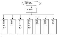
本设计包括路线的纵断面、横断面、边坡防护与加固、排水系统、涵洞、水泥混凝土路面设计、沥青混凝土路面设计和施工组织设计。纵断面设计是根据道路等级、沿线自然条件和构造物控制标高等,确定路线合适的标高、各坡段的纵坡度和坡长,并设计竖曲线。横断面设计是根据设计资料说明,并参照“标准横断面图”,画出路幅宽度,填或挖的边坡线,在需要设置各种支挡工程和防护工程的地方画出该工程结构的断面示意图。边坡防护与加固设计是根据边坡的高度,路基横断面形式进行植草或圬工防护。排水系统设计是根据横断面沟底标高确定流水方向,并设置涵洞。路面设计是根据公路等级、交通量进行路面结构设计。施工组织设计是根据沿线路段自然条件和工程量来确定施工进度和布置施工总平面图。
关键词:高速公路、路基、路面、排水、防护
The highway of Shangzhou to Shanyujie and Zhangxiang country to Koqian sectional design
(K53+200-K54+600)
ABSTRACT:This design is the highway of Shangzhou to Shanyujie and Zhangxiang country to Koqian sectional design. Design speed is 100km/h, subgrade width is 26 M, highway vehicle design load by road-I level, the total length of this highway is 1.4 kilometers.
The design includ the vertical section cross-sectional of the line design, slope protection and reinforcement, drainage systems, the culvert road design and the construction organization design . The profile design is based on grade of the road, the natural conditions and structures control elevation to determine the appropriate elevation of the road, the different slope of the vertical slope and the slope length and design of vertical curve. The main content of cross-sectional design is based on design information, in the light of the "standard cross-sectional map", drawing a way width, filling or digging slope of the slope, the need to set all kinds of support Engineering and protection engineering block where to draw the project structure of the cross-section diagram. Slope protection and reinforcement design is based on the height of the slope, cross-sectional form of grass embankment or masonry protection. Drainage system design is based on cross-sectional elevation of the ditch to determine the direction of flow, and set the culvert. Cement concrete pavement design is based on road grade, traffic volume pavement structure design. Construction design is based on the natural conditions along the roads and the construction quantities to determine the layout of the construction progress and the overall plan.
1.1.2.3.4.5.2.1.Keywords : Highway;Subgrade;Pavement;Drainage;Protection
目录
第一章 设计说明书 3
1.1 工程概况 3
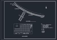
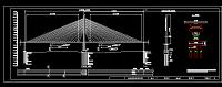
1.2 路线平面设计说明 5
1.3 路线纵断面设计说明 5
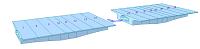
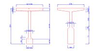
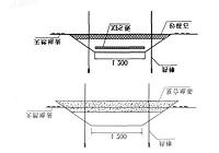
1.4 路基横断面设计说明 7
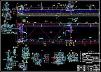
1.5 排水设计说明 9
1.6 涵洞设计说明 10
1.7 挡土墙设计说明 13
1.8 边坡稳定分析 22
1.9 路面设计说明 24
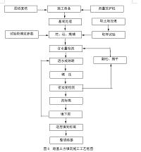
第二章 施工组织设计 41
2.1 编制依据及原则 41
2.2 工程概况 42
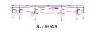
2.3 现场组织机构配置 42
2.4 总体施工方案 45
2.5 主要工程项目施工方案 46
2.6 主要工程项目施工方法 50
2.7 保证工程质量和工期的措施 62
2.8 文明施工保证措施 67
2.9 雨季的施工保证措施 68
参考文献 69
第一章 设计说明书
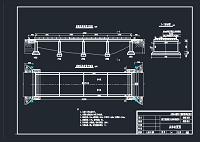
1.1 工程概况
1.1.1 概述
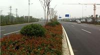
地质状况:本设计路段属秦岭山区。受复杂地质构造变动与内外地质应力长期作用,形成了山间盆地河谷丘陵为主的地貌。总体地势西北高,东南低;河谷两侧高,向丹江河谷降低。地貌单元为古溶原,溶原面积广阔,中间偶见风化溶蚀残余的石灰岩孤山,呈馒头状山包,高差不大,一般小于50m,基岩呈裸露或半裸露状。
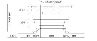
气候状况:本路线段属北温带亚湿润气候与北亚热带湿润气候过渡带,四季分明,冬春长,夏秋短,水热同季,垂直差异明显,具山地气候特点。年平均气温12.8~13.8℃,降水量比较丰富,降雨量725毫米,降水主要集中在夏秋两季。夏季间有冰雹,霜期始于10月下旬,终于次年3月底,冻土深度8.6~16.8cm。
地震情况:属秦岭山地,第三纪以来区域新构造活动比较强烈,总体以断块、地垒式抬升为特征,其间还有山间盆地形成。抬升表现为多级夷平面、多级(高低漫滩与一~四级)基座式阶地,还有峡谷、河流袭夺(截弯取直)及历史地震等现象。据国家质量技术监督局《中国地震动参数区划图》(GB18306-2001),本线路地震烈度为:商州区属Ⅶ度区,丹凤县属Ⅵ度区。
1.1.2 主要技术指标
1.公路等级:高速公路;
2.设计速度:100km/h;
3.路基宽度:双向四车道,宽26m;
4.采用的路面方案:
一、水泥混凝土路面,设计年限30年;
二、沥青混凝土路面,设计年限15年。
5.道路的使用性质和交通量:
方案一、水泥混凝土路面段基准期内设计车道标准轴载的作用次数为:10741724,属于重交通等级;
方案二、沥青混凝土路面段基准期内设计车道标准轴载的作用次数为:12987651,属于重交通等级;
6.路线设计起始点及设计高程:
起点桩号:K53+200 设计高程:650.0m
终点桩号:K1+400 设计高程:671.1m