

郭家港液压坝设计
摘要
郭楼港液压坝位于郭楼港桩号2+600处,是“平舆县水环境治理和生态修复”项目的重要组成部分。郭楼港现状河底宽度7m~15m,边坡1:0.5~1:2.5,河底比降1/1000~1/5000。河水质差,水体混浊,缺乏流动性。城市区雨污混流的现象,使得含有大量污染物的初期雨水就近排入河道,给水体带来较大污染负荷。现状河道滨水生境单一,沿河树木种类单一,缺乏生态修复和绿化,与城市市政设施、城市各类用地、城市空间环境未能有机融合。根据水系连通需要及水生态修复要求,需对现有河道进行重新规划设计,拟在2+600桩号处修建液压坝一座,满足平舆县水环境治理和生态修复工程的需要。
本项目水系包括小清河及其左岸支流北环渠、港湾港、二干退水渠,及右岸支流郭楼港、张路庄港、草河、七里河等。小清河是平舆县主要的防洪排涝河道,现状防洪标准为20年一遇,各支流河道均未治理过,现状比降较缓,流速较慢,泄流能力有限,加之长期泥沙淤积,河床断面缩小,从而降低了河道原有的防洪排涝能力,涝灾严重。本文对坝址处进行方案比选及枢纽布置;并对液压坝进行渗流稳定、消能防冲、闸室稳定及结构计算;对液压坝进行细部结构设计。
关键词:郭家港 液压坝 枢纽布置 渗流稳定 消能防冲 闸室稳定及结构计算
、
Abstract
The hydraulic dam of the Guo Lou port is located at 2+600 of the Guo Lou port pile number. It is an important part of the "Pingyu County water environment treatment and ecological restoration" project. The current width of the Kuo Lou port is 7m~15m, the slope is 1:0.5 to 1:2.5, and the riverbed gradient is 1/1000 to 1/5000. The water quality is poor, the water is cloudy and lack of fluidity. The phenomenon of mixed rain and pollution in urban areas causes the initial rainwater containing large quantities of pollutants to flow into the river nearby, which brings great pollution load to the water body. The current waterfront of the river is single, the species along the river is single, and the ecological restoration and greening are lack, and it is not integrated with urban municipal facilities, urban land use and urban space environment. According to the requirements of water system connectivity and water ecological restoration, the existing river course should be redesigned and designed. A hydraulic dam is built at the 2+600 pile number to meet the needs of water environment control and ecological restoration project in Pingyu county.
The water system of this project includes the Xiaoqing River and its left bank tributary north ring canal, port bay port, two dry retreating canal, and the right bank tributary Guo Gang, Zhang Lu Zhuang harbor, Cao River, Qilihe and so on. The Xiaoqing River is the main flood control and waterlogging channel in Pingyu county. The current standard of flood control is 20 years. All the tributary channels have not been treated. The current situation is slower, the flow velocity is slow, the discharge capacity is limited, and the long sediment deposition and the river bed section reduce, thus reducing the original flood control and drainage capacity of the river, and the flood disaster is serious. In this paper, the dam site is selected and the layout of the project is carried out, and the seepage stability, energy dissipation and erosion control, the stability of the gate chamber and the structure calculation are carried out on the hydraulic dam, and the detailed structure of the hydraulic dam is designed.
Key words: Guo Jia Gang hydraulic dam pivot layout, seepage stability, energy dissipation and scour chamber stability and structure calculation
目录
第一章 郭楼港液压坝设计原始资料 4
1.1、气象 4
1.2、水文 5
2、工程地质结论 7
2.1 地形地貌 7
2.2地层岩性 7
2.3 地震及地震动参数 7
2.4 地质结构 8
2.5 各岩土层物理力学性质 8
2.6 水文地质条件 8
2.7 工程地质评价 9
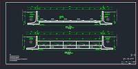
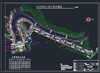
第二章 郭楼港液压坝坝址处进行方案比选及枢纽布置 9
2.1坝址比选方案对比 9
2.2枢纽布置 10
第三章 郭家港液压坝消能防冲计算 11
3.1 消能防冲水位组合 11
3.2 闸门初始开度及开启制度的确定 11
3.2.1 计算闸门初始开度e 11
3.2.2 闸门开启制度与初始开度 13
3.3 消力池设计 13
3.3.1 消力池形式的选定 13
3.3.2 消力池池深的计算 14
3.3.3 消力池长度的计算 16
3.3.4 消力池底板厚度的计算 17
3.3.5 消力池构造 17
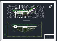
3.4 海漫长度的计算 18
3.5 海漫构造的确定 20
3.6 冲刷坑深度的计算,防冲槽尺寸的确定 20
3.6.1 冲刷坑深度的计算 20
第四章 液压坝渗流稳定计算 21
4.1 渗流计算水位组合 21
4.2 地下轮廓线布置 21
4.2.1 地下轮廓线布置 21
4.2.2 验算防渗长度 23
4.3 闸基渗流计算 23
4.3.1 计算地基有效深度 23
4.3.2 计算各典型段的阻尼系数 23
4.3.3 各典型段渗压水头损失计算 24
4.3.4 进、出口段修正及各区段渗压水头损失调整 24
第五章 闸室稳定及结构计算 28
5.1 闸室底板 28
5.2 闸墩 28
5.2.1 闸墩顺水流方向长度、闸墩高度 28
5.2.2 闸墩厚度、门槽位置和尺寸的拟定 30
5.3 闸门与胸墙 31
5.3.1胸墙 31
5.3.2闸门的选型与门重 32
5.3.3计算启闭力 32
5.3.4启闭机的选型 33
5.4 工作桥与启闭机房 33
5.5 工作桥设置高程,工作桥支墩的高度、尺寸的拟定 35
5.6 交通桥形式尺寸 36
5.7 闸室分缝布置与止水设置 36
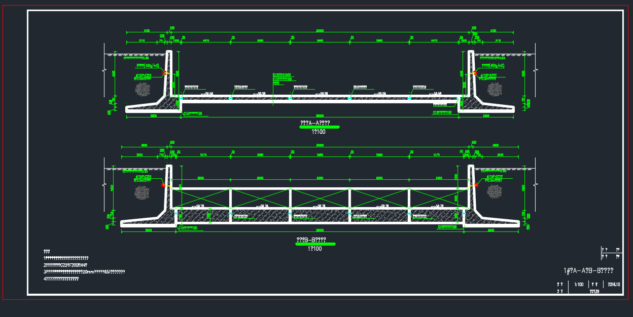
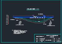
5.8 闸室布置图 37
5.9闸室稳定计算 38
5.9.1 自重 38
5.9..2 水重 39
5.9.3 浮托力计算 39
5.9.4 水平水压力 40
5.9.5 浪压力 41
5.9.6 渗透压力计算 42
5.9.7 闸室荷载汇总 42
5.9.10基底压力不均匀系数计算 43
5.9.11 闸室抗滑稳定计算 44
5.9.12地基承载力验算 44
第六章. 液压坝细部结构设计 45
6.1闸室底板内力计算 45
6.1.1 计算方法的选择 45
6.1.2 计算情况选择 45
6.1.3 弹性地基梁法计算地板内力(边孔一联) 45
6.1.4 弹性地基梁法计算地板内力(三孔一联) 109
6.2 闸底板配筋计算 120
6.3 闸底板的裂缝开展宽度验算 122
6.3.1计算方法 122
6.3.2 裂缝计算 122
参考文献 123
第一章 郭楼港液压坝设计原始资料
1.1、气象
项目区处于亚热带向暖温带过渡地带,属大陆性季风气候。其特征是雨热同季,四季分明,季风明显。多年平均气温14.8℃,多年平均无霜期229d,年平均日照总数2131小时。根据平舆县气象站1952-2015年实测降雨资料统计,多年平均降雨量为850mm,降雨量年际悬殊较大,年最大降雨量1473mm,年最小降雨量407mm。降雨量年内分布不均,多集中在6~9月份,约占全年降水量的60~70%;冬季雨雪稀少,约占全年降水量的5~10%。由于降水时空分布不均,年际变化大,所以该地区易发生涝灾与旱灾,严重影响全县经济发展。据统计,1951-2012年的62年中,平舆县只有9年风调雨顺,发生涝灾22年,22年旱灾,8年旱涝交替,1年霜灾,旱涝灾害频繁发生,并且旱灾发生的频率、持续时间均在增多和延长。
1.2、水文
1.2..1 暴雨洪水特征
本区域洪水主要由暴雨产生,非汛期水量较小,汛期水量急剧增加,洪水暴涨暴落,洪水过程持续时间一般为1天~3天,从洪水发生时间看,和暴雨的发生时间相对应,多发生在7月、8月。
1.2.2 径流
本次采用等值线图法估算天然年径流。
多年平均年径流深R查算《河南省水资源》(2007年)附图。
天然年径流量采用下式计算:
式中:—多年平均年径流量,万m3;
—多年平均年径流深,mm;
—流域面积。
查图得流域面积重心处的多年平均年径流深为190mm,Cv为0.71,Cs/Cv=2.0。经计算,不同频率设计成果见表1。
表1 径流成果表
河道 流域面积(km2) 均值 Cv Cs/Cv 频率P(%)
50 75 90
郭楼港 14.1 268 0.71 2 225 129 70
1.2.3 设计洪水成果
本次治理区均属于平原区。由于本地区无实测流量资料,设计洪水采用平原排涝模数公式计算洪峰流量。设计暴雨、洪峰流量等计算参数成果见表2。
表2 设计暴雨、洪峰流量等计算参数成果表
项目 设计频率
P=20% 10% 5% 2%
流域面积(km2) 14.1 14.1 14.1 14.1
点雨量均值(mm) 120 120 120 120
Cv 0.75 0.75 0.75 0.75
Cs/Cv 3.5 3.5 3.5 3.5
Kp值 1.37 1.93 2.51 3.31
设计面雨量P(mm) 164.4 231.6 301.2 397.2
前期影响雨量Pa(mm) 45 55 55 80
P+Pa(mm) 209.4 286.6 356.2 477.2
设计净雨R(mm) 101.0 172.5 239.3 356.3
峰量关系系数K 0.03 0.03 0.03 0.03
面积指数 0.75 0.75 0.75 0.75
洪峰折减系数α 1 0.9 0.8 0.7
洪峰流量(m3/s) 22.0 33.9 41.8 54.4
W24(万m3) 142.4 243.2 337.5 502.4
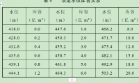
水面线推求后,设计水位见表3。
表3 郭楼港扩挖主槽后河道设计断面成果表
桩号 位置 设计断面 设计水位(m)
设计河底高程(m) 河道
比降 设计底宽(m) 设计边坡比 10年一遇水位 20年一遇水位
0+000 西环路交汇处 39.54 1/2500 15 1:2.5 42.01 42.46
0+200 39.46 1/2500 15 1:2.5 41.97 42.43
0+400 39.38 1/2500 15 1:2.5 41.93 42.40
0+600 39.30 1/2500 15 1:2.5 41.89 42.37
0+800 39.22 1/2500 15 1:2.5 41.85 42.35
1+000 39.14 1/2500 15 1:2.5 41.82 42.32
1+200 39.06 1/2500 15 1:2.5 41.79 42.30
1+400 38.98 1/2500 15 1:2.5 41.76 42.28
1+600 38.90 1/2500 15 1:2.5 41.73 42.26
1+800 38.82 1/2500 15 1:2.5 41.70 42.24
2+000 38.74 1/2500 15 1:2.5 41.68 42.23
2+200 38.66 1/2500 15 1:2.5 41.66 42.21
2+400 38.58 1/2500 15 1:2.5 41.64 42.20
2+600 液压坝 38.50 1/2500 15 1:2.5 41.62 42.18
2+800 入小清河处 38.42 1/2500 15 1:2.5 41.60 42.17
2.4 施工期洪水
根据《水利水电工程等级划分及洪水标准》(SL252-2000)及《水利水电工程施工组织设计规范》(SL303-2004),确定郭楼港施工期设计洪水标准为非汛期5年一遇。本流域无实测流量资料,施工期洪水采用相邻的许昌地区的综合流量模数成果计算。郭楼港5年一遇非汛期洪峰流量为0.63 m3/s。